


UAVFano
DJI Airport 2
Regular price
$6,399.00
Sale price
$6,399.00
Regular price
$6,399.00
Unit price

DJI Airport 2
Regular price
$6,399.00
Sale price
$6,399.00
Regular price
$6,399.00
Unit price
Product description
Shipping & Return
Product reviews
|
Category
|
Parameter Details
|
|
Basic Parameters
|
|
|
Product Name
|
DJI Airport 2
|
|
Total Weight
|
34 kg (excluding the aircraft). The fuselage is made of lightweight and high - strength aviation aluminum alloy and composite materials, which not only ensures the structural stability but also effectively reduces the overall weight, facilitating handling and installation.
|
|
Dimensions
|
When the hatch is open: Length 1228 mm, Width 583 mm, Height 412 mm;When the hatch is closed: Length 570 mm, Width 583 mm, Height 465 mm (the above data do not include the height of the anemometer, which is 145 mm, and all include the height of the tripod, which is 55 mm). The compact design can be adapted to various small - sized spaces. The hatch opening method has been optimized to quickly expose the internal drone, facilitating its rapid take - off and landing. The tripod has a certain shock - absorbing function, which can reduce the vibration impact on the airport and the drone caused by the uneven ground.
|
|
Input Voltage
|
100 - 240 V (AC), 50/60Hz. The wide input voltage range is compatible with the mains standards in most regions of the world, with strong adaptability.
|
|
Input Power
|
Up to 1000 W. When quickly charging the drone and operating the airport itself, the power can be automatically adjusted to ensure efficient and stable operation and avoid energy waste.
|
|
Operating Environment Temperature
|
-25°C to 45°C (when the ambient temperature is lower than - 20°C, the airport is in standby mode, and the aircraft cannot perform flight missions). It is equipped with an intelligent temperature control system. In low - temperature environments, the heating device can be automatically activated to maintain the normal operating temperature of key internal components. In high - temperature environments, heat can be quickly dissipated through efficient heat - dissipating fins and intelligent fans to ensure the stable operation of the equipment.
|
|
Protection Level
|
IP55. It has good dust - proof and water - proof performance, can effectively resist the intrusion of dust particles, and prevent water jets from all directions from damaging the equipment, making it suitable for long - term use in outdoor complex environments.
|
|
Number of Storable UAVs
|
1 unit. The internal space is precisely designed to stably place the compatible UAV, and at the same time, a reasonable space is reserved for batteries, accessories, etc. It also has an anti - collision buffer design to protect the safety of the UAV in the stowed state.
|
|
Maximum Allowed Landing Wind Speed
|
8 m/s. Through advanced landing assistance algorithms and high - precision sensors, combined with the flight stability system of the UAV itself, safe landing can be achieved at this wind speed, ensuring the continuity of mission execution.
|
|
Maximum Operating Altitude
|
4000 m. In high - altitude areas, by optimizing the parameters of the barometric sensor and the power system, the performance stability of the airport and the UAV is ensured, meeting the operation requirements in mountainous, plateau and other areas.
|
|
Satellite Reception Frequencies of RTK Base Station
|
Capable of simultaneously receiving GPS (L1 C/A, L2), BeiDou2 (B1l, B2l, B3l), BeiDou3 (B1l, B3l), GLONASS (L1, L2), Galileo (E1, E5B). The integration of multiple satellite systems significantly improves the accuracy and stability of positioning. Even in environments with weak satellite signals, accurate position information can be quickly obtained to ensure the accuracy of UAV flight and operation.
|
|
Positioning Accuracy of RTK Base Station
|
Horizontal: 1 cm + 1 ppm (RMS); Vertical: 2 cm + 1 ppm (RMS). Based on the advanced carrier - phase differential technology, positioning errors can be corrected in real - time, providing centimeter - level accurate positioning for UAVs, meeting the extremely high - precision positioning requirements in scenarios such as surveying and mapping, and inspection.
|
|
Structural Design
|
|
|
Design Features
|
A new integrated and lightweight design. Compared with the previous generation, the volume has decreased by 75%, and the weight has decreased by 68%. It can be carried by two people, greatly improving the installation flexibility and reducing the installation cost. The modular design concept is adopted, and each functional module can be quickly disassembled and assembled, facilitating maintenance and upgrading. The integrated molding process reduces the gaps between components, improving the overall sealing and stability.
|
|
Deployment - related
|
|
|
Deployment Time
|
The overall deployment time is approximately reduced from 5 hours to within 30 minutes. By using its own visual sensors to detect the occlusion of the surrounding environment, it can quickly determine whether the target area meets the deployment conditions. The visual sensors use high - resolution cameras and are combined with AI image recognition algorithms to quickly identify surrounding obstacles such as buildings and trees, and visually present them to the operator through the supporting software, facilitating timely adjustment of the deployment position.
|
|
Aircraft Compatibility
|
|
|
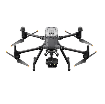
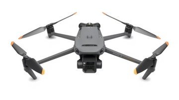
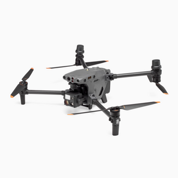
Compatible Models
|
DJI Matrice 3D/3TD aircraft or DJI Mavic 3 industry series aircraft. For different models, the fixing devices, charging interfaces, etc. inside the airport are all customized to ensure adaptability and compatibility.
|
|
Features of Matrice 3TD
|
Equipped with wide - angle, telephoto and infrared cameras, which can directly present visible light and thermal imaging pictures, suitable for security and inspection operations. The wide - angle camera can provide a broad field of view, facilitating the rapid scanning of large - area areas; the telephoto camera can capture details of distant targets; the infrared camera can detect abnormal object temperatures and discover potential safety hazards. It has an IP54 protection level, which can resist a certain degree of dust and water splashing, ensuring normal operation in harsh environments. The maximum forward flight time can reach 50 minutes, and the maximum effective operation radius is 10 km, meeting the needs of long - distance and long - time operations. With the DJI enhanced image transmission module, it can connect to the 4G network, achieving remote real - time image transmission and control. Even in remote areas, stable communication can be maintained. The battery can be cycled up to 400 times, reducing the use cost and improving the equipment utilization rate.
|
|
Features of Matrice 3D
|
Equipped with a telephoto camera and a mechanical - shutter wide - angle camera, which can meet the high - precision surveying and mapping requirements of 1:500. The telephoto camera is used for accurate measurement of distant targets, and the mechanical - shutter wide - angle camera can quickly capture large - area images. The two are combined to achieve high - precision surveying and mapping. It has an IP54 protection level. Relying on the lift - increasing mechanism to optimize flight efficiency, through the special design of the wing shape and lift - increasing device, the flight lift can be increased without increasing too much energy consumption. Combined with the sliding - ramp centering design of the apron and a variety of integrated positioning technologies, accurate and safe landing is achieved. The sliding - ramp design can guide the UAV to land smoothly and automatically center. The integrated positioning technology comprehensively uses GPS, visual positioning, inertial navigation, etc. to ensure landing accuracy. The maximum forward flight time can reach 50 minutes, and the maximum effective operation radius is 10 km. With the DJI enhanced image transmission module, it can connect to the 4G network, and the battery can be cycled up to 400 times.
|
|
Key Modules
|
|
|
Internal and External Fisheye Monitoring Cameras
|
Real - time display of the environmental changes inside and outside the cabin. Using 180° ultra - wide - angle fisheye lenses, it can monitor the internal equipment status of the cabin and the external surrounding environment in an all - round and non - blind - spot manner, facilitating the operator to detect abnormal situations in a timely manner, such as equipment failures and foreign object intrusions.
|
|
Environmental Monitoring System
|
Consists of sensors such as a rain gauge, anemometer, and thermometer, which can constantly sense weather changes. In case of severe weather, it can issue an alarm or suspend the flight mission in a timely manner. The rain gauge adopts a high - precision tipping - bucket design, which can accurately measure rainfall; the anemometer adopts a three - cup or propeller - type structure, which can quickly measure wind speed and direction; the thermometer uses high - precision components such as thermistors to accurately sense the ambient temperature. When severe weather such as heavy rain, strong wind, extreme high or low temperature is monitored, the system automatically sends an alarm to the operator and, according to the preset rules, controls the UAV to suspend or terminate the flight mission to ensure equipment safety.
|
|
Dual RTK Modules
|
Ensure that the airport can quickly enter the operation state. The aircraft can obtain accurate return - to - home position information without waiting for its own RTK to converge, and can complete the propeller detection and take - off in about 45 seconds at the fastest. The dual RTK modules adopt a master - slave backup design. When one module fails, the other can immediately take over the work to ensure the continuity and accuracy of positioning. The propeller detection uses high - precision photoelectric sensors and vibration sensors to quickly detect the installation status, dynamic balance, etc. of the propellers to ensure flight safety.
|
|
UPS Power Supply
|
Even in case of unexpected power failure, it can still work independently for more than 5 hours with the built - in battery, reserving sufficient time for the aircraft to return and land. The UPS power supply uses a high - performance lithium - battery pack, which has the characteristics of fast charging, long life, and high energy density. It can quickly switch to the battery - powered mode when the mains power is interrupted, ensuring the normal operation of the airport and UAV system and avoiding the loss or damage of the UAV due to power failure.
|
|
Charging Performance
|
Quickly charge the aircraft. It only takes about 32 minutes to charge from 20% to 90% of the battery capacity, achieving high - efficiency continuous operation. The intelligent fast - charging technology dynamically adjusts the charging voltage and current according to factors such as the battery type and remaining battery capacity, achieving fast charging while ensuring battery safety, reducing the waiting time of the UAV and improving the operation efficiency.
|
|
Intelligent Functions
|
|
|
Cloud Platform Compatibility
|
Compatible with the DJI SkyPort 2 cloud platform, supporting a variety of cloud - based intelligent operations. It can remotely control the airport and UAV equipment, quickly carry out route planning, issue flight plans and instructions, and collect multi - dimensional information. Through the SkyPort 2 cloud platform, the operator can monitor the status of the airport and UAVs in real - time from anywhere in the world with network connection, and perform remote settings and operations. The route - planning function is based on advanced path - optimization algorithms, which can generate the optimal flight route according to task requirements, geographical environment and other factors. It can collect multi - dimensional information including high - definition images, videos, thermal imaging data, positioning information, etc., and upload them to the cloud platform in real - time for subsequent analysis and processing.
|
|
Route Operations
|
When the UAV automatically executes route tasks in the air, it supports omnidirectional obstacle avoidance and automatically detours around obstacles. After completing the route task, SkyPort 2 generates a high - precision 3D model based on the collected route data, truly restoring the operation environment. The omnidirectional obstacle - avoidance system uses multiple sets of binocular vision sensors and ultrasonic sensors to perceive surrounding obstacles 360°. Combined with advanced obstacle - avoidance algorithms, it automatically plans detour paths. The SkyPort 2 cloud platform uses the principle of photogrammetry to process a large amount of collected image data to generate a high - precision 3D model, which can be used in fields such as terrain surveying and mapping, building monitoring, and environmental assessment.
|
|
Point - and - Fly
|
Through the point - and - fly function of SkyPort 2, the operator only needs to click the target point, and the aircraft can fly to the destination along an efficient and safe path. This function is based on advanced path - planning algorithms and real - time positioning technology. According to the target point position, the current position of the UAV and the surrounding environmental information, the optimal flight path is calculated to ensure that the UAV can quickly and safely reach the target, improving operation efficiency and flexibility.
|
|
Private Deployment
|
With the cloud - connecting API, it can be connected to a third - party cloud platform to achieve private deployment. Enterprises or institutions can connect the airport and UAV system to a private cloud platform according to their own data security needs, ensuring the security and controllability of data storage and transmission, meeting the extremely high - data - security requirements of industries such as government, finance, and energy.
|
|
Load Expansion
|
The aircraft is equipped with an E - Port interface, which supports the connection of third - party loads such as loudspeakers and searchlights. The operator can remotely control the third - party loads on the SkyPort 2 cloud platform. It also has an E - Port Lite interface, which supports the connection of parachutes. The E - Port interface adopts a standardized design, with good electrical compatibility and mechanical stability, and can be conveniently and quickly connected to various third - party loads. In security monitoring scenarios, a loudspeaker can be connected for remote warning; in night operations, a searchlight can be connected to illuminate the target area. The E - Port Lite interface is specially designed for simple loads such as parachutes to ensure the safe recovery of the UAV in case of emergency.
|
Shipping cost is based on weight. Just add products to your cart and use the Shipping Calculator to see the shipping price.
We want you to be 100% satisfied with your purchase. Items can be returned or exchanged within 30 days of delivery.